Vertical urbanisation is perceived as necessary to accommodate a growing population but is associated with severe risks for human well-being. It requires a profound understanding of how archi-tectural designs can ensure visually readable and liveable environments before it has been built. How-ever, current digital representation techniques fail to address the diverse interests of non-experts. Emerging biometric technologies may deliver the missing user information to involve (future) inhabit-ants at different stages of the planning process. The study aims to gain insight into how non-experts (visually) experience 3D city visualizations of designed urban areas. In two laboratory studies, univer-sity students were randomly assigned to view a set of the same level of detail images from one of two planned urban area developments in the Netherlands. Using eye-tracking technology, the visual behav-iour metrics of fixation count and duration and general eye-movement patterns were recorded for each image, followed by a short survey. The results show how visual behaviour and perception are remark-ably similar across different detail levels, implying that 3D visualizations of planned urban develop-ments can be examined by non-experts much earlier in the design process than previously thought.
DOCUMENT

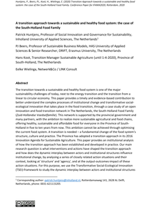
In urban planning, 3D modeling and virtual reality (VR) provide new means for involving citizens in the planning process. For municipal government, it is essential to know how effective these means are, to justify investments. In this study, we present a case of using VR in a municipal process of civic participation concerning the redesign of a public park. The process included codesign activities and involved citizens in decision-making through a ballot, using 3D-rendered versions of competing designs. In codesign, 3D-modeling tools were instrumental in empowering citizens to negotiate design decisions, to discuss the quality of designs with experts, and to collectively take decisions. This paper demonstrates that, in a ballot on competing designs with 1302 citizens, VR headsets proved to be equally effective compared to other display technologies in informing citizens during decision making. The results of an additional, controlled experiment indicate that VR headsets provide higher engagement and more vivid memories than viewing the designs on non-immersive displays. By integrating research into a municipal process, we contribute evidence of cognitive and engagement effects of using 3D modeling and immersive VR technologies to empower citizens in participatory urban planning. The case described in the paper concerns a public park; a similar approach could be applied to the design of public installations including media architecture.
DOCUMENT

Studies on city‐building games as educational tools show positive results in addressing different learning objectives, but also identify a missing link to reality, as they are mostly computer‐based. Given the differences between existing games and their capabilities, the exact function of these games in an urban planning curriculum is unclear. The city‐building game Cities: Skylines currently has three different versions (Digital, Tabletop, VR). Through an affordance analysis of the game’s three versions, this study analyses how the versions afford four primary knowledge dimensions, and in doing so identifies different educational applications for each version of Cities: Skylines in different planning disciplines. The results show that: (a) the board game is strong in fostering player participation and critical thinking more suited for the social and health studies, public policy, and citizen participation domains of urban planning; (b) the digital version functions as moddable simulator, ensuring familiarity with existing systems and monitoring their effects, useful in logistics and transportation planning; (c) the VR form viscerally involves players in the simulated processes, applicable in design‐focused segments of urban planning, such as sustainable design theory, housing, and land‐use management. The results of this study can help urban planning educators identify possible uses for different versions of Cities: Skylines.
MULTIFILE
Communication of climate-responsive urban design guidelines is becoming increasingly relevant in the light of climate adaptation challenges in cities. Widespread uptake in practice of such guidelines can be promoted by visualizations of the principles on which they are based. The “Really cooling water bodies in cities” research project developed and tested the required knowledge on visual communication. Evidence-based design guidelines assisting designers with creating cooler urban water environments were developed and communicated with 3D animations. The animations were shaped according to three core theoretical criteria about visual representations: “visual clarity”, “trust” and “interest”. We assessed in how far these criteria were met in an inquiry with design professionals, the target group of the design guidelines. The article concludes with recommendations for developing visual design guidelines in climate-responsive urban design: to weigh the level of detail, components and balance between site-specificity/abstraction (“visual clarity”); to make microclimatic processes visible without distorting them (“trust”); and to keep timing short and visual attractiveness high (“interest”). It is argued that taking these aspects into account and setting a clear correspondence between theoretical concepts, representation objectives and options, can largely benefit visual design guidelines communicating climate-responsive urban design knowledge.
DOCUMENT
Municipalities increasingly seek to include citizens in decision-making processes regarding local issues, such as urban planning. This paper presents a case study on using Virtual Reality (VR) in a process of civic participation in the redesign of a public park. The municipality included citizens in intensive co-design activities to create three designs for the park and engaged the neighbourhood community in co-decision, in the form of a ballot. Through the civic participatory process, we studied the effectiveness of using VR technology to engage the community in participating in the co-decision process. The three designs were presented using highly realistic 360˚ visualisations and the effects on engagement were compared between various devices: VR headsets, smartphones, tablets, and computers. Viewing the designs in 2D paper plans was also included in the comparison. The study included over 1300 respondents that participated in the ballot. A statistical analysis of the collected data shows that participants viewing the 360˚ rendered images with VR technology expressed a significantly higher engagement in the co-decision process than those using their computer at home or viewing 2D paper plans. The paper describes the complete participatory design process and the impact of the e-governance used on the target group as well as on the actors organizing the e-governance process. We discuss how the use of new technology and active presence of a voting-support team inspired citizens to participate in the co-creation process and how the investment in this procedure helped the local authorities to generate support for the plans and strengthen its relationship with the community. The use of realistic visualisations that can be easily assessed by citizens through user-friendly technology, enabled a large and diverse audience to participate. This resulted in greater visibility of municipal efforts to enhance the living environment of citizens and is therefore an important step in increased civic engagement in municipal policy-making and implementation.
DOCUMENT

Background: There is increasing interest in the role that technology can play in improving the vitality of knowledge workers. A promising and widely adopted strategy to attain this goal is to reduce sedentary behavior (SB) and increase physical activity (PA). In this paper, we review the state-of-the-art SB and PA interventions using technology in the office environment. By scoping the existing landscape, we identified current gaps and underexplored possibilities. We discuss opportunities for future development and research on SB and PA interventions using technology. Methods: A systematic search was conducted in the Association for Computing Machinery digital library, the interdisciplinary library Scopus, and the Institute of Electrical and Electronics Engineers Xplore Digital Library to locate peer-reviewed scientific articles detailing SB and PA technology interventions in office environments between 2009 and 2019. Results: The initial search identified 1130 articles, of which 45 studies were included in the analysis. Our scoping review focused on the technologies supporting the interventions, which were coded using a grounded approach. Conclusion: Our findings showed that current SB and PA interventions using technology provide limited possibilities for physically active ways of working as opposed to the common strategy of prompting breaks. Interventions are also often offered as additional systems or services, rather than integrated into existing office infrastructures. With this work, we have mapped different types of interventions and provide an increased understanding of the opportunities for future multidisciplinary development and research of technologies to address sedentary behavior and physical activity in the office context
DOCUMENT

Based on the theory of embodied cognition we developed NOOT, at tangible tool that allows marking audio-moments during creative sessions. A detailed analysis of using NOOT in practice lead to a reconceptualization of NOOT within processes of external scaffolding. It also spurred a new design project focused on reflection during group sessions
DOCUMENT

from the paper: "This paper presents a research endeavouring to model site work in a 4D BIM model. Next simulations are performed with this model in 5 scenarios including specific interventions in work organisation, notably changing positons of facilities for site workers. A case study has been done in a construction project in the Netherlands. The research has showed the possibility to model time use of site workers in 4D BIM. Next the research has showed potential to perform and calculate specific interventions in the model, and prospect realistic changes in productive time use as a result."
DOCUMENT

In this article we investigate the change in wetting behavior of inkjet printed materials on either hydrophilic or hydrophobic plasma treated patterns, to determine the minimum obtainable track width using selective patterned μPlasma printing. For Hexamethyl-Disiloxane (HMDSO)/N2 plasma, a decrease in surface energy of approx. 44 mN/m was measured. This resulted in a change in contact angle for water from <10 up to 105 degrees, and from 32 up to 46 degrees for Diethyleneglycol-Dimethaclylate (DEGDMA). For both the nitrogen, air and HMDSO/N2 plasma single pixel wide track widths of approx. 320 μm were measured at a plasma print height of 50 μm. Combining hydrophilic pretreatment of the glass substrate, by UV/Ozone or air μPlasma printing, with hydrophobic HMDSO/N2 plasma, the smallest hydrophilic area found was in the order of 300 μm as well.
DOCUMENT
The transition towards a sustainable and healthy food system is one of the major sustainability challenges of today, next to the energy transition and the transition from a linear to circular economy. This paper provides a timely and evidence-based contribution to better understand the complex processes of institutional change and transformative social-ecological innovation that takes place in the food transition, through a case study of an open innovation and food transition network in The Netherlands, the South-Holland Food Family (Zuid-Hollandse Voedselfamilie). This network is supported by the provincial government and many partners, with the ambition to realize more sustainable agricultural and food chains, offering healthy, sustainable and affordable food for everyone in the Province of South-Holland in five to ten years from now. This ambition cannot be achieved through optimising the current food system. A transition is needed – a fundamental change of the food system’s structure, culture and practice. The Province has adopted a transition approach in its 2016 Innovation Agenda for Sustainable Agriculture. This paper provides an institutional analysis of how the transition approach has been established and developed in practice. Our main research question is what interventions and actions have shaped the transition approach and how does the dynamic interplay between actors and institutional structures influence institutional change, by analysing a series of closely related action situations and their context, looking at 'structure' and 'agency', and at the output-outcomes-impact of these action situations. For this purpose, we use the Transformative Social-Ecological Innovation (TSEI)-framework to study the dynamic interplay between actors and institutional structures influencing institutional change. The example of TSEI-framework application in this paper shows when and how local agents change the institutional context itself, which provides relevant insights on institutional work and the mutually constitutive nature of structure and agency. Above institutional analysis also shows the pivotal role of a number of actors, such as network facilitators and provincial minister, and their capability and skills to combine formal and informal institutional environments and logics and mobilize resources, thereby legitimizing and supporting the change effort. The results are indicative of the importance of institutional structures as both facilitating (i.e., the province’s policies) and limiting (e.g. land ownership) transition dynamics.
DOCUMENT