Urban densification is a key strategy to accommodate rapid urban population growth, but emerging evidence suggests serious risks of urban densification for individuals’ mental health. To better understand the complex pathways from urban densification to mental health, we integrated interdisciplinary expert knowledge in a causal loop diagram via group model building techniques. Six subsystems were identified: five subsystems describing mechanisms on how changes in the urban system caused by urban densification may impact mental health, and one showing how changes in mental health may alter urban densification. The new insights can help to develop resilient, healthier cities for all.
LINK
Amsterdam faces the challenge of accommodating 50,000 to 90,000 new homes in the next five to ten years. That is equivalent to 10% of the city’s current total housing stock. The new homes have to be built within the existing urban fabric. This will entail high densities and the construction of new ‘un-Dutch’ typologies with high-rise residential buildings. Densification is currently accelerating in many Western cities and high-rise living environments are gaining ground as today’s typology. Yet these new typologies come with potentially serious risks to the liveability of cities in general and those new environments in particular (Asgarzadeh et al. 2012; Lindal and Hartig 2013; Gifford 2007). Urban designers and (landscape) architects are challenged to prevent and soften the negative impact that is often associated with extremely densified environments. This entails mitigating contradictive demands: to create high-density capacity andshape streetscapes that relate to a human scale. Designers might resort to the large body of applied design solutions and theories, yet these tend to be derived from more traditional urban fabrics of low-density developments (for example: e.g. Sennett 2018; Haas 2008; Jacobs 1993; Banerjee and Southworth 1990; Alexander et.al. 1977; Jacobs 1961).Therefore, the question of the research project Sensing Streetscape is if the classical design solutions are without any alterations, applicable in these new high density settings and able to create streetscapes with a human scale. A combination of emerging technologies and principles from both worlds; neuroscience and architecture offer the opportunity to investigate this question in-depth as a relation between the designed and the visually perceived streetscape.
DOCUMENT

Abstract from AMS Scientific Conference '24, Amsterdam, Netherlands.In the two-year Nature-Based Area Development study researchers at four Dutch universities collaborated with planning professionals in cities, regions and companies to investigate how nature-based urban development can become a forceful reality. The study applied a combination of methods such as co-research sessions with consortium partners, in-depth interviews with experts and a multiple case study analysis of best practices in the Netherlands and abroad.Keywords: nature-based, area development, densification, urban ecosystem services, planning instruments
DOCUMENT
This study investigated the urban growth dynamics of urban regions. The study area was the Marmara Region, one of the most densely populated and ecologically diverse areas in Turkey. Using CORINE land cover data for 2006, 2012, and 2018, the study utilized multiple correspondence analyses and cluster analyses, to analyze land cover changes. The resulting maps, visualized in GIS, revealed the rapid urban transformation of the regional structure, formerly comprised of four distinct areas, into a more complex structure, in which densification and sprawl occur simultaneously. Our findings demonstrated a dissonance between the spatial dynamics of the Marmara Region during the study period, and the capacity and scope of the simultaneously initiated regional policies and mega‐projects. This uncoordinated approach has endangered the region’s sustainable development. The paper, therefore, discusses the importance of land use planning and transboundary collaboration for sustainable regional development. Beyond the local case, the results contribute to critical theories in regional planning by linking theory and practice.
DOCUMENT

Urban densification continues unabated, even as the possible consequences for users’ eye-level experiences remain unknown. This study addresses these consequences. In a laboratory setting, images of the NDSM wharf were shown to university students primed for one of three user groups: residents, visitors and passers-by. Their visual experiences were recorded using eye-tracking and analyzed in combination with surveys on self-reported appreciation and restorativeness. On-site surveys were also administered among real users. The results reveal distinct eye-movement patterns that point to the influence of environmental roles and tasks and how architectural qualities steer people’s visual experience, valence and restoration.
DOCUMENT
Built environments are increasingly vulnerable to the impacts of climate change. Most European towns and cities have developed horizontally over time but are currently in the process of further densification. High-rise developments are being built within city boundaries at an unprecedented rate to accommodate a growing urban population. This densification contributes to the Urban Heat Island phenomenon and can increase the frequency and duration of extreme heat events locally. These new build-up areas, in common with historic city centres, consist mainly of solid surfaces often lacking open green urban spaces.The Intervention Catalogue is the third publication in a series produced by the Cool Towns project and has been designed as a resource for decision makers, urban planners, landscape architects, environmental consultants, elected members and anyone else considering how to mitigate heat stress and increase thermal comfort in urban areas. Technical information on the effectiveness of the full array of intervention types from trees to water features, shading sails to green walls, has been assessed for their heat stress mitigation properties, expressed in Physiological Equivalent Temperature (PET). The results shown in factsheets will help the process of making an informed, evidence based, choice so that the most appropriate intervention for the specific spatial situation can be identified.
DOCUMENT

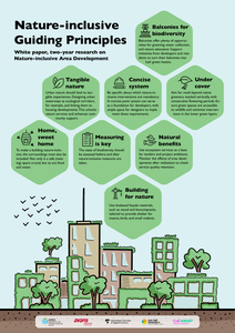
Urban nature enhancement is a theme that needs to be considered across different scales. From pocket parks and façade-greening to urban green infrastructure, biodiversity thrives best through connectivity.In the SIA-project, Nature-inclusive Area Development, four universities of applied sciences - Aeres University of Applied Sciences, Avans University of Applied Sciences, Amsterdam University of Applied Sciences, and Van Hall Larenstein University of AppliedSciences- researched three levels of area development to accelerate the transition to nature-inclusive area development. The study consisted of three case studies: Waarder Railway Zone (building), Knowledge Mile Park (KMP - street - Amsterdam), and AlmereCentre-Pampus (area).
DOCUMENT
The accelerated densification of Western European cities driven by economic growth has major spatial implications for their overall livability. Often, new homes must be built within an existing urban fabric, creating higher density environments. However, the impact on the experience of these high-density environments at eye level remains unstudied and unknown. This chapter reviews two experiments that sought to understand the unconscious reception of streetscapes using eye-tracking technology to investigate the sequence of users’ (visual) experience, their behavior and perception. The research project seeks to establish more ‘evidence-based’ design guidelines for streetscapes in high-rise urban settings.This chapter reviews two experiments that sought to understand the unconscious reception of streetscapes using eye-tracking technology to investigate the sequence of users’ experience, their behavior and perception. Eye-tracking results of Experiment 1 show that the movement of pedestrians, cyclists and cars crossing the street created the most eye fixation for most participants. In general, the eye-tracking results from Experiment 2 show that participants’ eyes followed the length of the facades toward the end of the street and the horizon. The preliminary results suggest that the assessed design principles ‘Active ground floor’ and ‘Ornate facades’ might be important factors in predicting dominant eye patterns. The chapter explores the application of eye-tracking technology in urban design to gain a deeper understanding of the physical-behavioral interrelationship of streetscapes in European high-density built environments. The accelerated densification of Western European cities driven by economic growth has major spatial implications for their overall livability.
DOCUMENT
Habitat fragmentation caused by urbanization and climate change are important drivers of biodiversity decline and ecosystem degradation (McKinney, 2002). Governmental inaction results in cascade effects, such as the extinction of species and the weakening of ecosystem services that citizens depend on. Alarming studies show the continuing loss of nature within European cities as they densify further to meet the demand for housing (Balikçi et al., 2022). The housing market is currently impacted negatively by economic factors and municipalities often respond by scaling back their sustainability ambitions. To avoid cosmetic greening of cities, the eco-social value of urban developments and their contribution to climate-change adaptation need to be made measurable. Developing nature-based urban areas offers opportunities to increase socio-ecological resilience (McPhearson et al., 2015; Spanjar et al., 2022).In the two-year Nature-Based Area Development study researchers at four Dutch universities collaborated with planning professionals in cities, regions and companies to investigate how nature-based urban development can become a forceful reality. The study applied a combination of methods such as co-research sessions with consortium partners, in-depth interviews with experts and a multiple case study analysis of best practices in the Netherlands and abroad. Malmö and Stockholm are frontrunners in applying innovative green planning instruments such as Green Area Factor to meet high environmental ambitions (Kruuse, 2011). These instruments were also analysed and compared with eco-city projects in the Netherlands to identify their effectiveness in fostering nature and ecosystem services.The analysis shows barriers in governance and spatiality between public and (semi-)private developments. Policy silos and ownership divisions often lead to standalone interventions that negatively impact social and ecological connectedness and projects’ potential for climate-change adaptation. Nature-based urban developments require a proactive effort to understand the precise ecological demands across scales and how they can be harnessed effectively in these complex planning processes. The results of the study provide key lessons and inspiration to enable authorities to implement more effective nature-based planning instruments.
MULTIFILE

DOCUMENT

