aving access to accurate and recent digital twins of infrastructure assets benefits the renovation, maintenance, condition monitoring, and construction planning of infrastructural projects. There are many cases where such a digital twin does not yet exist, such as for legacy structures. In order to create such a digital twin, a mobile laser scanner can be used to capture the geometric representation of the structure. With the aid of semantic segmentation, the scene can be decomposed into different object classes. This decomposition can then be used to retrieve cad models from a cad library to create an accurate digital twin. This study explores three deep-learning-based models for semantic segmentation of point clouds in a practical real-world setting: PointNet++, SuperPoint Graph, and Point Transformer. This study focuses on the use case of catenary arches of the Dutch railway system in collaboration with Strukton Rail, a major contractor for rail projects. A challenging, varied, high-resolution, and annotated dataset for evaluating point cloud segmentation models in railway settings is presented. The dataset contains 14 individually labelled classes and is the first of its kind to be made publicly available. A modified PointNet++ model achieved the best mean class Intersection over Union (IoU) of 71% for the semantic segmentation task on this new, diverse, and challenging dataset.
DOCUMENT
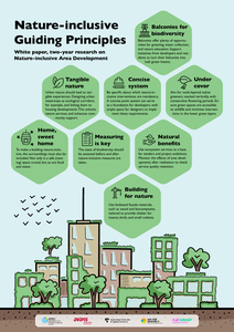
Urban nature enhancement is a theme that needs to be considered across different scales. From pocket parks and façade-greening to urban green infrastructure, biodiversity thrives best through connectivity.In the SIA-project, Nature-inclusive Area Development, four universities of applied sciences - Aeres University of Applied Sciences, Avans University of Applied Sciences, Amsterdam University of Applied Sciences, and Van Hall Larenstein University of AppliedSciences- researched three levels of area development to accelerate the transition to nature-inclusive area development. The study consisted of three case studies: Waarder Railway Zone (building), Knowledge Mile Park (KMP - street - Amsterdam), and AlmereCentre-Pampus (area).
DOCUMENT

Abstract: Climate change is related with weather extremes, which may cause damages to infrastructure used by freight transport services. Heavy rainfall may lead to flooding and damage to railway lines, roads and inland waterways. Extreme drought may lead to extremely low water levels, which prevent safe navigation by inland barges. Wet and dry periods may alternate, leaving little time to repair damages. In some Western and Middle-European countries, barges have a large share in freight transport. If a main waterway is out of service, then alternatives are called for. Volume- and price-wise, trucking is not a viable alternative. Could railways be that alternative? The paper was written after the unusually long dry summer period in Europe in 2022. It deals with the question: If the Rhine, a major European waterway becomes locally inaccessible, could railways (temporarily) play a larger role in freight transport? It is a continuation of our earlier research. It contains a case study, the data of which was fed into a simulation model. The model deals with technical details like service specification route length, energy consumption and emissions. The study points to interesting rail services to keep Europe’s freight on the move. Their realization may be complex especially in terms of logistics and infrastructure, but is there an alternative?
MULTIFILE

DOCUMENT
Peer-reviewed artikel over semantische segmentatie van point clouds.
MULTIFILE

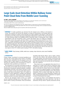
To reduce greenhouse gas emissions from the transport sector, shifting to rail transport is crucial. This transition will increase the demand on existing rail infrastructure, necessitating large-scale monitoring to maintain its resilience. Point cloud data are an ideal candidate for this purpose, as they provide immediate, precise 3D geometric information independent of illumination conditions. This study investigates two object detection models, the PointPillar and the CenterPoint model, to automatically create a digital representation of the rail environment. Using a custom open dataset, these two models are evaluated to detect masts, tension rods, signals, and relay cabinets. A mean Average Precision (mAP@0.5) of 70.6% is achieved. A unique contribution of this study is an in-depth analysis of the locational error in terms of the x and y components of the detected positions. This analysis reveals that location accuracy is not yet sufficient for engineering applications. The analysis indicates that the largest contribution to this error originates from the random error. Additionally, this study demonstrates that transfer learning effectively reduces the labeling burden. For instance, when using 25% of the training data, the average Precision (AP) for the tension rod class improves from 9.5% without transfer learning to 70.8% with transfer learning.
MULTIFILE

De gemeente Den Haag buigt zich al jaren over de revitalisering van de winkelstraat Stationsweg. Ze typeert de straat, die tussen het station Hollands Spoor en de binnenstad ligt, als ‘de rode loper’. Dit roept het beeld op van een aantrekkelijk route waar men plezier aan beleeft. De vraag is in hoeverre deze visie aansluit bij de alledaagse beleving van bezoekers. Diverse passanten en klanten zijn benaderd om dit te onderzoeken. Er blijkt een behoorlijke discrepantie te bestaan tussen de manier waarop zij de straat gebruiken en beleven en het idee van ‘de rode loper’. Voor veel passanten is de straat vooral een efficiënte route naar de binnenstad en zeker niet een straat waar men naar de etalages kijkend kalmpjes doorheen loopt. Voor veel klanten is de straat geen route, maar juist een bestemming waar ze onder meer hun dagelijkse boodschappen doen en vertrouwd raken met anderen. The Municipality of The Hague has been making efforts to revitalize the shopping street Stationsweg for several years. The street, located between the Hollands Spoor railway station and city centre, is characterized as ‘the red carpet’. This gives the street the image of an exclusive shopping destination. However, the question is to what extent this image matches the everyday experiences of its visitors. To determine this, several passers-by and customers were approached. There appears to be a substantial discrepancy between how they experience the street and the image of ‘the red carpet’. For many passers-by, the street is simply an efficient route to the city centre, rather than a street for window shopping or strolling. Furthermore, instead of a route, many consider the street a destination, where they do their daily shopping and meet others.
DOCUMENT
