Storm sewers are known to significantly contribute to annual pollutant loads to receiving water bodies. The storm sewers of the city of Almere discharge the stormwater of 1384 ha of impervious area via 700 storm sewer outfalls (SSOs) to the local receiving water system. This water system suffers from eutrophication and long term build-up of pollutant levels in the sediment bed. In order to be able to select the most effective stormwater management strategy, the municipality of Almere and Water Authority Zuiderzeeland have launched a 2 year extensive monitoring project to measure the stormwater quality and the potential impact of source control and end of pipe measures to decrease the emission via SSOs. Source control measures, such as removal of illicit connections and increasing the cleaning frequency of gully pots showed to be most effective. The potential impact of end of pipesolutions based on settling showed to be very limited due to the low settleability of solids in the storm water of Almere at the SSOs.
DOCUMENT

Sedimentation devices have been widely implemented to remove suspended solids and attached pollutants from stormwater before entering surface waters. The treatment performance of these best management practices (BMPs) on fine particles is rarely investigated in a standardized way. To overcome this information gap a reliable and standardized testing procedure is formulated.Four devices have been tested on their suspended sediments removal efficiency at different discharges and particle sizes, using the newly developed standardized full scale test method. The observed removal rates of the facilities with a storage volume in the order of 1.5 m3 and settling surface around 1 m2 drop to low removal efficiencies at flow rates of 10 l/s or more. For small sized sediments (up to 63 μm) the removal efficiency is below 50%. The results of the experiments can be used to improve both the design and the dimensions of stormwater treatment devices.
LINK
Most research on hydrological risks focuses either on flood risk or drought risk, whilst floods and droughts are two extremes of the same hydrological cycle. To better design disaster risk reduction (DRR) measures and strategies, it is important to consider interactions between these closely linked phenomena. We show examples of: (a) how flood or drought DRR measures can have (unintended) positive or negative impacts on risk of the opposite hazard; and (b) how flood or drought DRR measures can be negatively impacted by the opposite hazard. We focus on dikes and levees, dams, stormwater control and upstream measures, subsurface storage, migration, agricultural practices, and vulnerability and preparedness. We identify key challenges for moving towards a more holistic risk management approach.
DOCUMENT
Schepen in moeilijkheden op zee leveren vaak besluitvormingsproblemen op tussen de scheepseigenaar/kapitein en de kuststaat. Kuststaten en met name de lokale overheden willen een probleem schip graag zo ver mogelijk weg sturen van hun gebied terwijl de eigenaar/kapitein zijn schip graag zo snel mogelijk naar de kust, een beschutte locatie of haven wil brengen. Het onderzoek geeft onderbouwing voor de besluitvorming rond schepen in moeilijkheden, zowel voor de zeescheepvaart als de betrokken besluitvormers van oeverstaten. Het product van het project is: een, op uitgewerkte scenario’s per scheepstype en lading gebaseerde besluitvormingsprocedure voor zeeschepen in moeilijkheden
DOCUMENT

VHL University of Applied Sciences (VHL) is a sustainable University of AppliedSciences that trains students to be ambitious, innovative professionals andcarries out applied research to make a significant contribution to asustainable world. Together with partners from the field, they contribute to innovative and sustainable developments through research and knowledge valorisation. Their focus is on circular agriculture, water, healthy food & nutrition, soil and biodiversity – themes that are developed within research lines in the variousapplied research groups. These themes address the challenges that are part ofthe international sustainability agenda for 2030: the sustainable developmentgoals (SDGs). This booklet contains fascinating and representative examplesof projects – completed or ongoing, from home and abroad – that are linked tothe SDGs. The project results contribute not only to the SDGs but to their teaching as well.
DOCUMENT

This study focuses on SME networks of design and high-tech companies in Southeast Netherland. By highlighting the personal networks of members across design and high-tech industries, the study attempts to identify the main brokers in this dynamic environment. In addition, we investigate whether specific characteristics are associated with these brokers. The main contribution of the paper lies in the fact that, in contrast to most other work, it is quantitative and that it focuses on brokers identified in an actual network (based on both suppliers and users of the knowledge infrastructure). Studying the phenomenon of brokerage provides us with clear insights into the concept of brokerage regarding SME networks in different fields. In particular we highlight how third parties contribute to the transfer and development of knowledge. Empirical results show, among others that the most influential brokers are found in the nonprofit and science sector and have a long track record in their branch.
DOCUMENT

Objective: In myocardial perfusion single-photon emission computed tomography (SPECT), abdominal activity often interferes with the evaluation of perfusion in the inferior wall, especially after pharmacological stress. In this randomized study, we examined the effect of carbonated water intake versus still water intake on the quality of images obtained during myocardial perfusion images (MPI) studies. Methods: A total of 467 MIBI studies were randomized into a carbonated water group and a water group. The presence of intestinal activity adjacent to the inferior wall was evaluated by two observers. Furthermore, a semiquantitative analysis was performed in the adenosine subgroup,using a count ratio of the inferior myocardial wall and adjacent abdominal activity. Results: The need for repeated SPECT in the adenosine studies was 5.3 % in the carbonated water group versus 19.4 % in the still water group (p = 0.019). The inferior wall-to-abdomen count ratio was significantly higher in the carbonated water group compared to the still water group (2.11 ± 1.00 vs. 1.72 ± 0.73, p\0.001). The effect of carbonated water during rest and after exercise was not significant. Conclusions: This randomized study showed that carbonated water significantly reduced the interference of extra-cardiac activity in adenosine SPECT MPI. Keywords: Extra-cardiac radioactivity, Myocardial SPECT, Image quality enhancement, Carbonated water
DOCUMENT

Global society is confronted with various challenges: climate change should be mitigated, and society should adapt to the impacts of climate change, resources will become scarcer and hence resources should be used more efficiently and recovered after use, the growing world population and its growing wealth create unprecedented emissions of pollutants, threatening public health, wildlife and biodiversity. This paper provides an overview of the challenges and risks for sewage systems, next to some opportunities and chances that these developments pose. Some of the challenges are emerging from climate change and resource scarcity, others come from the challenges emerging from stricter regulation of emissions. It also presents risks and threats from within the system, next to external influences which may affect the surroundings of the sewage systems. It finally reflects on barriers to respond to these challenges. http://dx.doi.org/10.13044/j.sdewes.d6.0231 LinkedIn: https://www.linkedin.com/in/sabineeijlander/ https://www.linkedin.com/in/karel-mulder-163aa96/
MULTIFILE

Stormwater runoff has severe negative and direct impact on the quality of surface waters and groundwater. The impact can cause chemical and heavy-metal pollution. Applying well established methods to map pollutants in urban areas and specifically in Nature-Based Solutions (NBS), such as Sustainable UrbanDrainage Systems (SuDS) is a step towards improving the water quality in the urban water cycle. Traditional mapping of pollutants by the means of soil samples is costly, which is the main reason why the environmental-technical functioning of rainwater facilities has not been investigated on a large scale andsystematically. X-ray fluorescence (XRF) is a known analysing method for finding metals and other components, for laboratory analysis and portable instruments. In this work we propose a new approach of mapping method for pollutants in-situ, such as heavy metals in soil in SuDS, with case studies from theNetherlands where swales were implemented 20 years ago. In situ XRF measurements is a quick and costefficient analysis for heavy meatal mapping in the respect to contaminated soil. In situ XRF measures of various elements, including heavy metals is carried out in a quickscan and accurate manner and measures both qualitatively and quantitatively. It makes the time-consuming and costly interim analyses by laboratories superfluous. In this study, we suggest a new methodology approach for in situ mapping of pollutants in various swales that were implemented from 20 to 5 years ago. The results differ due to multiple factors (age, use of materials, storage volume, maintenance, run off quality, etc.). Several locations reached unacceptable levels, above the national thresholds for pollutants. The spatial distribution of pollutants in the over 30 swales mapped in the Netherlands show that the preferred water flow in theSuDS controls the spreading of pollutants. The swales investigated are presented in an interactive way with the open source tool www.climatescan.nl, containing more than 100 swales, part of which has been investigated with in situ XRF measurements. The research results are of great importance for all stakeholders in (inter)national cities that are involved in climate adaptation. SuDS is the most widely used method for storing stormwater and infiltrating in the Netherlands. However, there is still too little knowledge about the long-term functioning of the soil of these facilities.
DOCUMENT

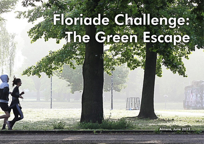
Almere is a green city where the greenery extends into the centre through a framework of nature, forests, parks and canals. With this green environment, Almere fulfils an important condition for a liveable city, where it is pleasant to live and work. An important goal for the municipality is to challenge its residents to develop a healthy lifestyle by using that green framework.But what really motivates Almeerders to go outside to exercise, enjoy the surroundings and meet each other? Are there sufficient green meeting or sports facilities nearby? Could the routes that connect the living and working environment with the larger parks or forests be better designed? And can those routes simultaneously contribute to climate adaptation?With the Green Escape Challenge, we invited students and young professionals to work on these assignments together.
DOCUMENT